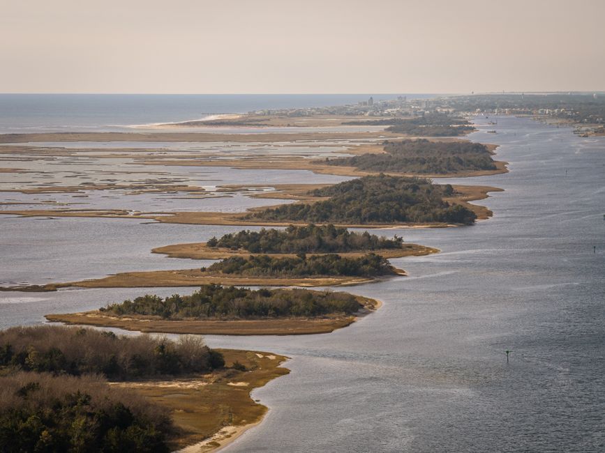
Barrier islands are elongated, narrow landforms composed primarily of sand and other unconsolidated sediments that run parallel to the mainland coast. They are separated from the mainland by a lagoon, bay, or marsh, and they absorb much of the wave energy generated by open ocean conditions. Found along approximately 15 percent of the world’s coastlines, these islands are among the most dynamic coastal environments on Earth. Their very existence depends on a delicate balance between sediment supply, wave action, tidal currents, and sea level. Understanding how they form and why they migrate is essential for anyone involved in coastal planning, engineering, or environmental science.
The formation of barrier islands has intrigued geologists for more than a century. Several competing theories attempt to explain their origins, each supported by field evidence from different parts of the world. Regardless of which mechanism dominates in a given location, barrier islands share a common trait: they are constantly reshaped by the forces of the sea. Storms, hurricanes, and even seasonal changes in wave direction can move entire sections of an island within hours or days. This inherent mobility creates both natural resilience and significant management challenges.
In this article, we examine the processes behind barrier island formation and migration. We consider the various hypotheses proposed by coastal scientists, the factors that control how quickly islands move, and the implications for coastal communities and infrastructure. We also discuss how professionals, including those at Coastline Surveys, use monitoring and analysis to better understand these dynamic systems.
Origins: How Barrier Islands Form
Several theories have been proposed to explain the origin of barrier islands. The most widely accepted is the drowned coastal plain theory, which suggests that as sea level rose after the last ice age, low-lying coastal areas were flooded, leaving behind sandy ridges that became the nuclei of barrier islands. Another prominent idea is the spit accretion theory, where longshore drift extends a spit across a bay or inlet, eventually detaching it from the mainland. A third hypothesis, the barrier bar theory, posits that storm waves and tidal currents pile sediment into submerged bars that gradually build up to the surface.
Each theory finds support in different settings. For example, the drowned coastal plain mechanism is often invoked for the barrier chains along the United States’ Atlantic and Gulf coasts, where broad continental shelves and abundant sediment supply exist. Spit accretion is observed on coasts with strong unidirectional longshore currents and irregular shorelines. Barrier bar formation is common in areas with high wave energy and abundant sand. In reality, most barrier islands likely formed through a combination of these processes, influenced by local geology, sea level history, and sediment availability.
Sediment supply is the fundamental ingredient for barrier island formation. Without a steady input of sand and gravel, any initial accumulation will be quickly eroded by waves and currents. Sources of sediment include rivers, eroding cliffs, and the reworking of older coastal deposits. The rate and type of sediment delivery determine not only whether an island forms but also its shape, size, and long-term stability. Human activities such as dam building and river management can reduce sediment delivery, potentially altering barrier island dynamics.
Once an island emerges, it enters a phase of continuous adjustment. Waves rework the beachface, tides sculpt the inlets and back-barrier marshes, and wind transports sand inland to form dunes. Over time, these processes create a characteristic zonation: a sandy beach on the ocean side, a dune ridge, a flat back-barrier area, and a marsh or mudflat on the lagoon side. The entire system is maintained by the constant exchange of sediment among these zones, a concept known as the coastal sediment budget.
Introducing a process-based perspective, Coastline Surveys specialises in the collection and interpretation of coastal data, which can help to clarify how sediment moves within these systems. Their work contributes to an improved understanding of barrier island behaviour, although no single dataset can fully capture the complexity of these environments.
Migration Mechanisms: The Rollover Process
Barrier islands are not stationary features. They migrate in response to changes in sea level, wave climate, and sediment supply. The most important process driving migration is overwash, which occurs when storm waves and high water levels push sand from the beach and dunes across the island onto the back-barrier area. Over time, this landward transfer of sediment causes the entire island to move inland, a process known as rollover.
Rollover is the primary mechanism by which barrier islands maintain their width and height as sea level rises. As the ocean side erodes under rising seas, the island does not simply drown; instead, sand is transported to the lagoon side, raising the back-barrier surface. In this way, the island can keep pace with moderate rates of sea level rise. However, if the rate of sea level rise exceeds the rate of sediment supply and overwash, the island may narrow, breach, or even disintegrate.
In addition to overwash, inlets play a crucial role in barrier island migration. Inlets are gaps in the island chain that allow water to flow between the ocean and the lagoon. They can form during storms when the island is breached, and they can migrate along the island through the action of longshore currents. Inlet migration redistributes sediment and can lead to significant changes in island shape and position. Some inlets are ephemeral, closing after a short time, while others persist for decades or centuries.
Human interventions, such as dredging and jetties, can disrupt natural inlet dynamics. Stabilising an inlet may protect navigation channels but can also starve adjacent shorelines of sediment, leading to accelerated erosion. Coastal managers must therefore weigh the benefits of short-term stability against the potential long-term consequences for barrier island migration.
The rate of island migration varies widely. In some locations, it can be a few metres per year; in others, particularly during storms, it can exceed tens of metres in a single event. Factors controlling migration rate include sea level trend, wave energy, tidal range, sediment supply, and the presence of vegetation that stabilises dunes and back-barrier flats. Because these factors interact in complex ways, predicting future migration patterns remains a scientific challenge.
Challenges for Coastal Management
The dynamic nature of barrier islands presents significant challenges for coastal management. Unlike stable landforms, barrier islands are constantly changing, making it difficult to define property boundaries, plan infrastructure, and implement protection measures. Coastal communities often face a dilemma: they can attempt to hold the shoreline in place, or they can allow the island to migrate naturally, which may require relocating buildings and roads.
Hard engineering structures, such as seawalls and groynes, are sometimes used to combat erosion. However, these structures can exacerbate erosion in adjacent areas by disrupting the natural movement of sediment. Moreover, they may prevent overwash and rollover, which are essential for the island’s ability to adapt to rising sea levels. As a result, many coastal managers now favour soft engineering approaches, such as beach nourishment and dune restoration, which work with natural processes.
Beach nourishment involves adding sand to the beach to widen it and provide a buffer against erosion. While this can be effective in the short term, it is expensive and must be repeated periodically. The sand used for nourishment must be compatible with the native sediment to avoid ecological impacts. Furthermore, nourishment does not address the underlying cause of erosion, such as sea level rise or sediment deficiency, and may simply delay the inevitable migration.
Another management challenge is the protection of sensitive ecosystems. Barrier islands support a range of habitats, including dunes, maritime forests, salt marshes, and lagoons. These habitats are vital for wildlife, including migratory birds, sea turtles, and fish. Human activities, such as vehicle traffic, construction, and pollution, can degrade these ecosystems. Balancing human use with conservation requires careful planning and regulation.
In the United Kingdom, coastal management is guided by shoreline management plans (SMPs) that assess the risks of coastal change and set out long-term policies. These plans often involve trade-offs between different stretches of coast, recognising that protection of one area may affect another. The dynamic nature of barrier islands means that management strategies must be adaptive, evolving as new data and understanding emerge.
Organisations such as Coastline Surveys contribute to this effort by providing accurate, up-to-date information on coastal morphology and sediment transport. Their expertise supports evidence-based decision-making, though the inherent uncertainties in predicting coastal change mean that management will always involve a degree of risk.
Future Outlook and Research Directions
The future of barrier islands is closely tied to climate change. As global sea levels continue to rise, the pressure on these landforms will intensify. While some islands may be able to migrate landward and persist, others may be lost entirely if sediment supply is insufficient or if human interventions inhibit natural processes. The Intergovernmental Panel on Climate Change (IPCC) projects that sea level could rise by 0.3 to 1.0 metres by 2100, depending on greenhouse gas emissions. Such rises would challenge even the most resilient barrier systems.
Research into barrier island dynamics is ongoing. Scientists use a variety of tools, including remote sensing, sediment coring, and numerical modelling, to understand how these islands respond to changing conditions. Numerical models simulate the interactions between waves, tides, sediment, and sea level, allowing researchers to test different scenarios and make projections. However, models are simplifications of reality and come with inherent uncertainties, particularly regarding the frequency and magnitude of future storms.
One area of active investigation is the role of storms in barrier island evolution. Storms can both destroy and build islands, depending on their characteristics and the pre-storm condition of the island. For example, a moderate storm may deliver a pulse of sediment to the back-barrier, aiding rollover, while an extreme storm may cause breaching and significant land loss. Understanding these thresholds is critical for predicting future changes.
Another research focus is the interaction between barrier islands and adjacent environments. Barrier islands are part of a larger coastal system that includes estuaries, tidal flats, and the inner continental shelf. Changes in one part of the system can have repercussions elsewhere. For instance, sediment trapped in an estuary may reduce the supply available to barrier islands, leading to erosion. A holistic, system-wide approach is therefore essential for effective management.
Ultimately, the fate of barrier islands will depend on a combination of natural processes and human decisions. By improving our understanding of these dynamic landforms, we can better anticipate changes and develop strategies that balance human needs with the preservation of these valuable coastal resources. The work of coastal scientists and surveyors remains indispensable in this endeavour, providing the data and insights needed to navigate an uncertain future.